Trail Mountain bike Le Montet - Bocage - Le Montet - Photo
 tracegps
tracegps

User

© OpenStreetMap contributors
Length
Length
53 km
Max alt
Max alt
486 m
Uphill gradient
Uphill gradient
1071 m
Km-Effort
Km-Effort  
67 km
Min alt
Min alt
274 m
Downhill gradient
Downhill gradient
1071 m
Boucle
Boucle
Yes
Creation date :
2014-12-10 00:00:00.0
Updated on :
2014-12-10 00:00:00.0

(0 Reviews)

Mountain bike
Mountain bike
3h30
Difficulty : Medium

Scan this QR Code to open this trail in the SityTrail application

FREE GPS app for hiking

Logo SityTrail SityTrail

IGN / Geographical institutes

Download SityTrail from the App Store Download SityTrail from Google Play

Logo SityTrail SityTrail World

The world is yours!

Download SityTrail from the App Store Download SityTrail from Google Play Download SityTrail on Huawei AppGallery

About

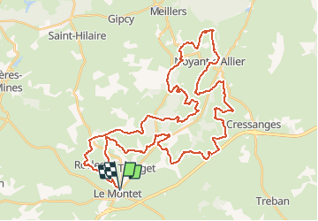
Trail Mountain bike of 53 km to be discovered at Auvergne-Rhône-Alpes, Allier, Le Montet. This trail is proposed by tracegps.

Description

Joli circuit avec de super points de vue sur le Bocage. Passage devant la pagode de Noyant d'Allier.

Elevation profile

Photos

Positioning

Country:
France
Region :
Auvergne-Rhône-Alpes
Department/Province :
Allier
Municipality :
Le Montet
Location:
Unknown
Start:(UTM)
504229 ; 5139631 (31T) N.

Trails nearby

Trail Walking Tronget - Circuit de Tronget  - Photo
Walking
tracegps

Walking

Medium
Tronget, Auvergne-Rhône-Alpes, Allier, France
8.9 km | 10.7 km-effort
2h 15min
Yes
Trail Mountain bike Le Montet - Bocage  25 - Le Montet - Photo
Mountain bike
tracegps

Mountain bike

Easy
Le Montet, Auvergne-Rhône-Alpes, Allier, France
23 km | 28 km-effort
1h 30min
Yes
Trail Walking Rocles - Le sentier des noisetiers - Rocles - Photo
Walking
tracegps

Walking

Easy
Rocles, Auvergne-Rhône-Alpes, Allier, France
4.4 km | 5.6 km-effort
1h 4min
Yes


Close
My subscriptions